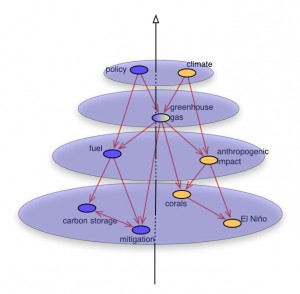
Given a proximity metric, it is possible to map the scientific landscape made by the aggregation of publications over time, as a multi-level object, featuring at the micro-level: a lexical network made by terms or key phrases linked according to their semantic distance, at the macro-level: a network of thematic fields defined as the groupings of cohesive items of the lexical network.
The construction of these thematic fields is usually  performed thanks to network clustering algorithm. In this illustration the clique percolation algorithm (CFinder) is being used to produce overlapping clusters. It means that a node can naturally belong to several clusters if it is indeed densely connected to several distinct groups of nodes.
The clustering operation can be repeated as many times as necessary to get more and more synthetic maps. At the second step, instead of categorizing key-phrases together, thematic fields are being clustered, etc.
Article: Jean-Philippe Cointet, David Chavalarias (2008) Multi-level Science mapping with asymmetric co-occurrence analysis: Methodology and case study, 267-276. In NETWORKS AND HETEROGENEOUS MEDIA 3 (2). [pdf]